- Development of the Elderslie release area will be in the form of an urban village, adjoining and connected to the existing suburban development in Elderslie and Narellan. The village will consist of a variety of housing forms, in landscaped garden and natural settings and a small neighbourhood centre.
- The new suburban area must integrate with the existing Elderslie and Narellan communities and with Kirkham Park by suitable low-level road, pedestrian and cycle links. Internally, the subdivision pattern will promote accessibility by pedestrians and cyclists. The areas of higher residential densities will be located close to the public transport corridors and within close proximity to the local commercial and educational facilities and the open space corridors.
- The urban village will be serviced by local and regional public transport services that provide a viable alternative to private vehicles. The Camden Valley Way—Camden By-pass link road will facilitate improved access to the Camden Bypass and form a natural extension linking with the Macarthur Centre.
- The visually and culturally significant “Rheinberger’s Hill”, the gateway to Camden from the north, must remain a visually prominent open landscape. Housing must not encroach on to Rheinberger’s Hill. Large lot housing should be sympathetically located behind the hill to the east of the saddle in the ridgeline. It must be of a density that provides a transition from the Studley Park Golf Course to the suburban housing area. Studley Park and Rheinberger’s Hill will form a significant open space break between Narellan and Elderslie.
- Hilder Street and Lodges Road continue to provide evidence of the historic development of the area. While land in the vicinity of these roads will undergo development and change, the alignment of the roads must be maintained.
- Visually and ecologically significant vegetated areas must be preserved, by inclusion in the open space network, based principally on the creek lines as significant biological corridors.
- District views and view corridors between historic items and culturally significant places must be preserved.
- Stormwater management must be ecologically sustainable by using local control measures, which will relate strongly to the creek line corridors.
Related Studies
This section must be read in conjunction with the following supporting documents which contains controls, guidelines and recommendations. These are additional to those set out in this subsection and must be considered when submitting a development application:
- Landscape Master Report (December 2001) by Context Landscape Architects.
- Heritage Assessment Elderslie Urban Release Area (July 2001) Godden Mackay Logan.
- Heritage Report for 150 Lodges Road (August 2003) by Godden Mackay Logan.
- Heritage Report for Rheinberger’s Hill (November 2002) by Godden Mackay Logan.
- Water Cycle Master Plan Report (December 2001) by J. Wyndham Prince Pty Ltd.
- Traffic and Transport Report (September 2002) by Masson Wilson Twiney.
- Flora and Fauna Report (December 2001) by Conacher Travers.
Note: The Elderslie urban release area master plan is show in Figure S1-1. It identifies the road connections and indicative lot yield to be achieved. Variations to the master plan should be considered if the principles set out in this DCP are complied with.
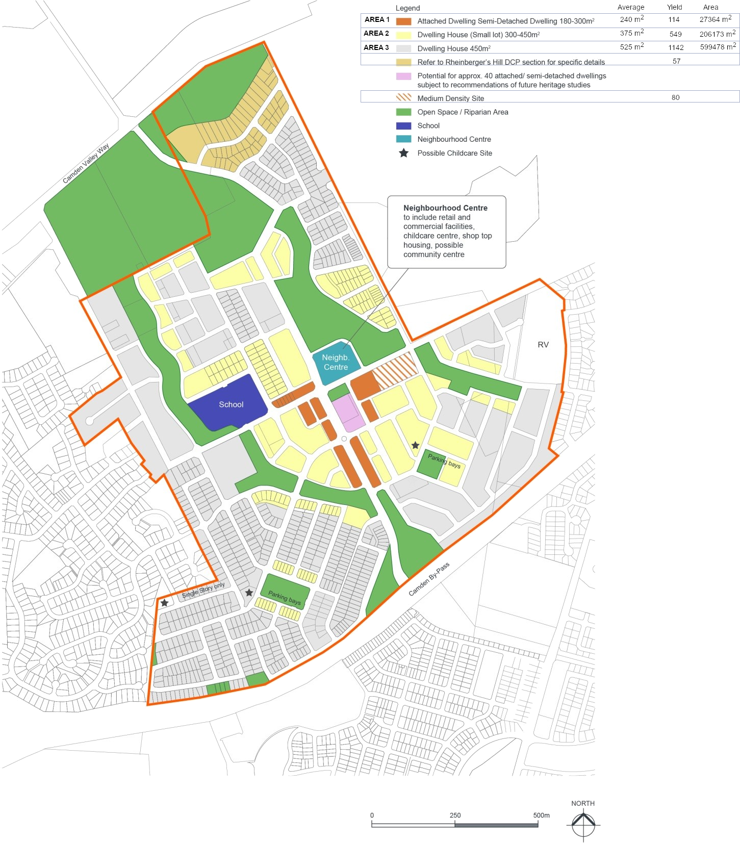 Figure S1-1: Elderslie Master Plan